TEL +44 151 602 0304 INFO@MARLAN-TECH.CO.UK

Liverpool City Region Future Innovation Fund enables advances in understanding our coast

Synoptic-4d portal wide a

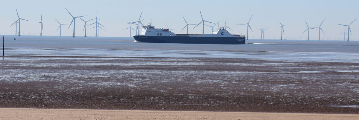
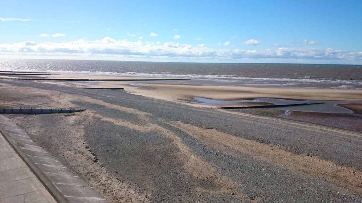
Many areas of coast are dynamic, literally never looking the same twice; a deep understanding of how and why these changes happen is something that humans have been grappling with for generations.

Beach with groynes

We live in an age where available technology is enabling this level of understanding. Earth observation and remote-sensing techniques produce vast volumes of data, offering tremendous value to a broad range of users. However, storing, loading and processing these large datasets is beyond the current capabilities of many users’ equipment and systems.

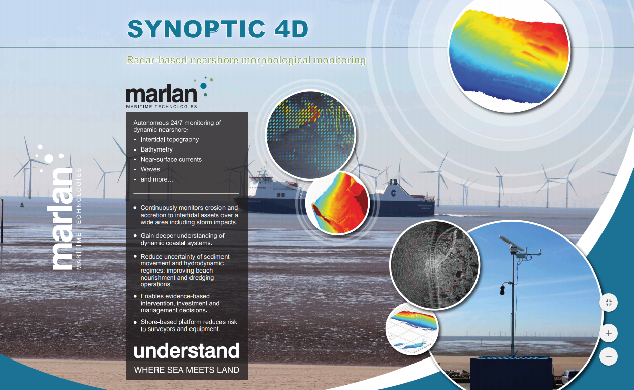
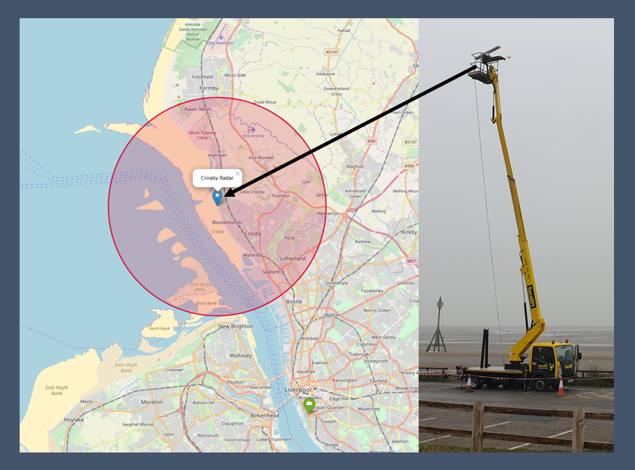
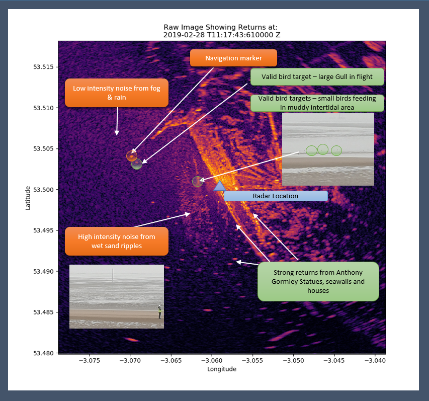
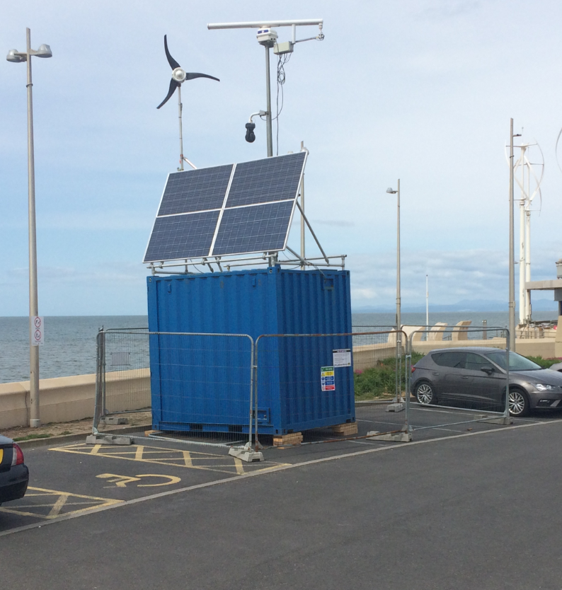
Our Synoptic 4D service uses radar to collect coastal data 24 hours a day, 7 days a week. Until now, we have been processing all the data on high performance workstations, analysing the results and digesting them into reports that answer specific questions for the user. This was a great place to start, but isn’t a solution that will scale well to meet our growing UK demand, let alone overseas. We recognised the need for a better way of delivering this coastal information to our customers that is more accessible to them and presents the data in format that allows them to explore regions of interest.

Most GIS (Geographic Information System) tools are not well suited to navigation in time as well as 3D space, so we started looking for a partner to develop a web-based platform that included this temporal aspect.

Folks at Hexagon were interested in applying their M.App Enterprise platform to help us solve some of the problems of coastal monitoring and management, particularly access to continually updated intertidal topography, bathymetry and hydrodynamic data.

Hexagon Geospatial are global leaders in geospatial software, with over 60 years of experience. In M.App Enterprise, Hexagon has brought together this experience to give a single platform capable of analysing, managing, and delivering geospatial (mapping, imagery) data. New technologies like artificial intelligence (AI), cloud computing, and spatial model processing are within M.App Enterprise and it is already in use with customers worldwide.

After a year of getting to know one another we partnered with Hexagon Geospatial just into 2020.

Then, like many, we were forced to deal with the challenges of working from home, redesigning safe working practices, supply chains shutting down, caring for those more seriously affected by the pandemic and countless uncertainties of lockdown #1.

Before long, summer was upon us and our intention to build a tool for our users to explore their data themselves was going nowhere. Our users and future customers were also dealing with a plethora of unimagined scenarios at work and home and many projects slowed to an apparent halt.

Then… a glimpse of the solution… word on the street of an innovation grant for Liverpool City Region companies. We had to wait for the announcement to appear on the www then go! Summer 2020 was not the summer we had been planning (who’s was) but restrictions were easing and we had a backlog of work to deliver for some customers who had thankfully been very understanding of the circumstances. Instead of sunbathing, learning another language or musical instrument, we bid for the Liverpool City Region Combined Authority – Future Innovation Fund. We thought it would go unnoticed by many companies who were similarly catching up after lockdown hiatus, but it transpires it was oversubscribed by a long way and we were fortunate to be one of 14 companies awarded a grant.

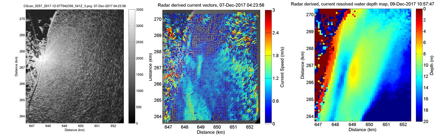
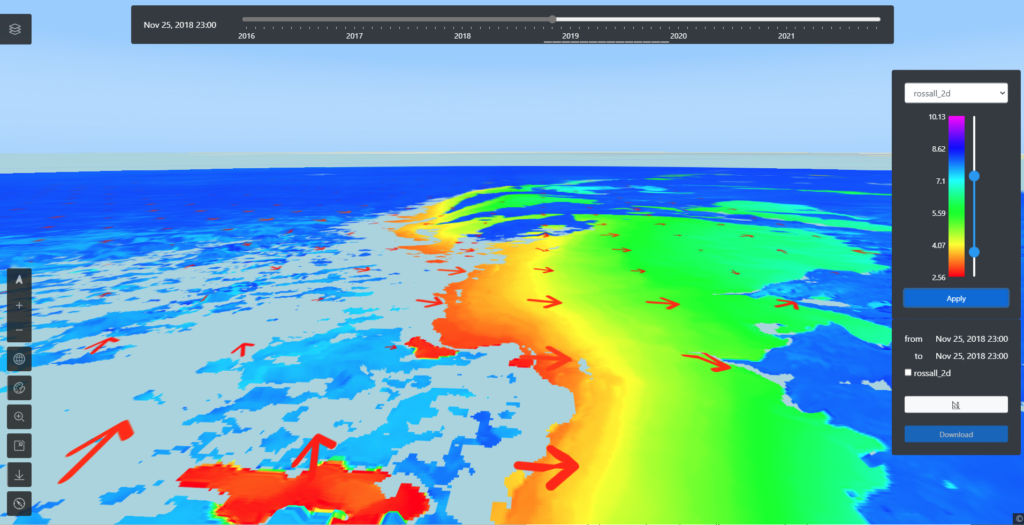
Today we’re pleased to announce beta trials of our new Synoptic 4D data exploration portal with some of our users. Below are some sneak peeks of it with data from the Rossall coastal defence scheme for which we have been collecting data for 2 years.

Synoptic-4d portal wide a


Benefits and features of Synoptic-4D portal: Synoptic-4D portal zoom

Synoptic-4D portal detail with currents

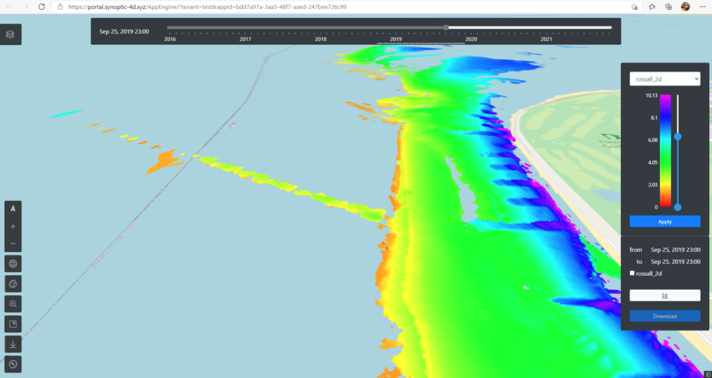
  • Web-based platform hosts your data so you don’t have to. Easily accessed from any web browser, not only from your office
  • Configurable layers of data over a global basemap to understand cause and effect together
  • Timeslider provides navigation through time of all layers simultaneously, enabling the examination and visualisation of time-variant phenomena
  • Focus mode allows you to concentrate on a on a smaller part of your view
  • 2D and 3D modes allow the maps to be viewed in plan and perspective views enabling a greater connection to the physical environment
  • Find and identify features in the terrain data with easy slide & click palette customisation
  • Downloading data for analysis in external/existing tools is as easy as drawing a box and selecting the layers and times of interest
Posted in articles

Developing innovative systems for improved port navigation

The Marlan team are delighted to be working alongside the University of Liverpool and Satellite Oceanographic Consultants Ltd (SatOC) in their new project funded by MarRI-UK (The Maritime Research and Innovation UK). This project forms part of the £1.5m initiative awarded to eleven organisations by MarRI-UK, to aid the development of technological innovation which improves UK Maritime services and operations.

The Maritime sector will see significant changes as technology advances the ways in which it operates and environmental concerns pose new and ever more demanding requirements for the industry. A recent article by Sarah Kenny, Vice Chair of Maritime UK highlights the importance of investment and focus on these vulnerable, but vital communities that could level up following the Covid-19 pandemic.

The University of Liverpool’s project, ‘Assuring safe port navigation by applying machine learning (ML) to wave data for automated monitoring of changes in nearshore bathymetry’, will utilise a combination of satellite and radar, along with data analysis methods to effectively monitor changes in sub- and intertidal bathymetry. This will support port authorities and operators in ensuring that navigation is both safe and efficient.


Alex Sinclair, Managing Director at Marlan said, “we all have a fantastic opportunity to change so much of how we live and work at the coast.  There are so many community engagement vectors for improving lives near coast, but also changing perceptions. Marlan Maritime Technologies works with ports and harbours, and now increasingly local authorities to provide data which enables better solutions for ports and coastal defence managers. This aids the reduction of capital and operating CO2 emissions, and can enable imaginative engineers and policy makers to make decisions based on evidence of the nearshore environment, rather than having to rely on models sometimes built using less than ideal input data.

Since we’ve been working at coastal sites, we’ve been truly amazed by the interest of the public we meet out at sites, they show genuine interest and many have a strong desire to contribute to the better understanding of the changing coast. I’m looking forward to reading the next!”

To read more about the project, see here


Posted in articles, case

Marlan’s Director of Research wins ‘Rising Star Award’ at the Mersey Maritime Industry Awards 2020! 


Director of Research at Marlan, Dr Cai Bird was awarded the ‘Rising Star’ category at the recent Mersey Maritime Industry Awards 2020. Cai had been shortlisted as one of three finalists for the category, with the team having won the Mersey Maritime Innovation Award back in 2018. The prestigious awards event took place on Friday 6 March at the spectacular St George’s Hall in Liverpool and included awards for various categories across the maritime sector.  


Cai has been working with the Marlan team for over 7 years following funding of his PhD at the University of Liverpool, developing a new method of coastal monitoring using marine radar. Cai has published numerous academic papers contributing to the knowledge and application of remote sensing within the coastal management sector. Together with the rest of the team, including the National Oceanography Centre and the University of Liverpool, he has designed an array of software and data analysis techniques to deepen our understanding of coastal dynamics. 


Commodore Phil Waterhouse presented the Rising Star Award to Dr Cai Bird


The awards ceremony demonstrates the vital contributions made to the maritime industry from the many companies and organisations within Merseyside. In addition to Marlan’s award, colleagues from the University of Liverpool and LJMU won the ‘Environmental Impact’ category for their collaboration on the LCEI (Low Carbon Eco-Innovatory) PhD program. 


The Marlan team would like to congratulate the other award winners of the evening. It was truly a special night and a wonderful opportunity to acknowledge the achievements of fellow colleagues across the maritime industry. Well done everyone! 


Posted in articles, case

Working with the next generation in marine science


The Marlan team were recently delighted to host an intern student, welcoming a new team member on a four-week project to deliver exciting results. Eilean MacDonald, a second year Oceanography student at the University of Southampton, is passionate about marine science, maths and physics and, in particular, new ways of gaining insight into the natural world. Showing great initiative, she approached Marlan at Ocean Business and asked if she could carry out a work placement with the team, focusing on methods to better understand the coastal environment.


Eilean used the data gathered from Marlan’s Synoptic 4D radar deployment at Crosby beach and used the wave inversion technique to develop new forms of data analysis. In this project, she applied her newly-acquired programming and data science skills along with her existing mathematical skills, specifically using vector calculus to quantify the magnitude and directions of surface currents in Liverpool bay.

Eilean is now assisting Marlan with the writing of a paper which will use data analysed during this project to reveal interesting coastal phenomena within the Liverpool bay area. During her time working with Marlan, Eilean has had the opportunity to learn the fundamental elements of software development and gain first-hand experience of data science within the coastal monitoring industry.


The Wave Inversion Technique


The wave inversion method works by analysing a sequence of radar images containing waves and looking at the frequency of those waves. Over time the algorithm can lock onto a wave signal that changes as it passes over different water depths according to the linear dispersion relationship. Eilean looked at how the data quality changed over the course of a tidal cycle in Liverpool Bay.

Notice how the signal cleans up as the tide rises and the waves are better able to propagate across the sand banks into the channel. Marlan have several months of data from this site and the team are excited to see how dredging and siltation affect channel depths over time.


Reflecting on her time working with Marlan, Eilean commented, “my experience at Marlan was great and the team were excellent to work with and be around. It gave me an insight into the industry and its workings as well as providing me with challenges to improve my knowledge and skills.”

Marlan will be deploying a Synoptic 4D radar system at Pevensey bay this year for the University of Southampton. Eilean will be working closely with academics and PhD students at the University to help analyse the data gathered throughout the deployment. This will further expose her to data analysis techniques for remote sensing and enhance her knowledge of observational data science. Marlan hopes to work with her again in the future and she will no doubt have a successful career, whatever path she chooses.


Promoting development and diversity


Eilean’s time working with Marlan reflects their belief in the importance of welcoming and supporting the next generation into the workplace. Young adults need these opportunities to gain insight into different industries and be able to use that experience to inform their career choices. Marlan feels that it is also vital to foster and support diversity; encouraging different problem-solving approaches and alternative points of view within their team.

Dr Melanie Sinclair, director at Marlan, commented “our time with Eilean was a great success – we very much enjoyed having her as part of the team. It has inspired us to look further into working with universities, schools and colleges and offering projects to more students from a range of different experiences and backgrounds.”

Posted in articles, case

Cast your votes now for the Mersey Maritime Industry Awards 2020!

Voting is now open for the upcoming Mersey Maritime Industry Awards. All colleagues within the industry are welcome to take part and vote for who they believe should win.

Marlan’s Director of Research, Dr Cai Bird has been nominated for the ‘Rising Star’ award for his achievements within the coastal environment monitoring sector (see here). As a result of Cai’s work, we can now turn radar images into 3D maps of beach elevations and seabed depths. These are continuously updated as the radar scans, providing us with the story of beach movement through different seasons and weather conditions.

Over the past 7 years that Cai has been working with Marlan, his numerous publications and innovative software developments have enabled the industry to more deeply understand the ever-changing coastal dynamics which are vital for both our society and economy.


The University of Liverpool and LJMU have also been shortlisted for the ‘Environmental Impact’ award for their ongoing doctoral training program LCEI (Low Carbon Eco Innovatory). Marlan currently work with and fund 2 PhD students within the LCEI program, Sam Godfrey and Phil Knight, whose important research aims to further improve the coastal monitoring industry.

Cast your votes

Voting is open now here and colleagues are encouraged to cast one vote for each category. Consider watching the finalist videos to help you make your decisions.

Voting will close at midday on Friday 14th February.

The Marlan team would like to once again wish all participants the very best of luck in the awards.

Posted in articles, case

Marlan’s Director of Research Dr Cai Bird nominated for ‘Rising Star’ at the Mersey Maritime Industry Awards 2020

The Marlan team are delighted that their Director of Research, Dr Cai Bird has been shortlisted by the industry as one of three finalists in the ‘Rising Star’ category of the Mersey Maritime Industry Awards 2020 taking place on Friday 6 March. This follows them receiving the prestigious Mersey Maritime Innovation award back in 2018.

Marlan are proud of the work Cai has done over the 7 years that he has been working with them. They funded his PhD project which he completed in 2015 at the University of Liverpool to validate a new method of monitoring intertidal areas using their marine radar installations.


Since then, Cai has published numerous academic papers to help widen the knowledge and use of remote sensing technologies in the maritime and coastal management industry. Cai has written ground-breaking algorithms and software to more deeply understand the dynamic coastal areas that are so important to our society and economy.

Cai has continued to work with colleagues in research organisations including the National Oceanography Centre, involving projects such as the successful WireWall Project which sought to use a unique wire-based technology to measure wave overtopping. The WireWall Project, by Dr. Jenny Brown, was awarded the positive impact award last year.

Community

The Mersey Maritime Industry Awards serve as an important acknowledgement of the excellent contributions that many companies and organisations make within the Merseyside area. Marlan are honoured to be shortlisted alongside their colleagues from the University of Liverpool and LJMU, who have been nominated for the ‘Environmental Impact’ category. This application is focused on the LCEI PhD program and the Marlan team have thoroughly enjoyed working with and providing financial support for their 2 PhD students, Sam Godfrey and Phil Knight through the LCEI program.

Industry voting

The finalists are now listed on the Mersey Maritime website and will soon invite industry colleagues to vote on who they believe should be awarded each category. All industry professionals are encouraged to take part in this process, as it is incredibly useful for all members working in the industry to see the fantastic work and achievements taking place across the many diverse sectors.

Please join the Marlan team in wishing all participants the best of luck as they look forward to celebrating another great year at the awards evening on 6 March, St George’s Hall, Liverpool.

Posted in articles, case

Marlan celebrates successful Flood & Coast conference 2019


The team at Marlan have been busy following up on their most successful conference and trade show yet. The Flood and Coast conference seeks to advance the debates surrounding flood and coastal erosion risks and response. The event brings together government and trade bodies, local authorities and industry to deliver innovative technology and solutions to control the increasing risk of rising sea levels and floods around our coastlines.


The show involved months of preparation by the team at Marlan, from organising new graphics and material, to planning and preparing presentation material. The session on “Digital, data innovation and opportunities” was extremely well attended by senior members of the environment agency and industry. Organised by Andy Moores, Manager of the Environment Agency’s FCERM R&D  programme, the session featured a series of rapid presentations opening with a summary of the importance and need for coastal monitoring data by Dr Charlie Thompson, Director of the Channel Coast Observatory.

Different data collection techniques were then presented including WIREWALL and Synoptic 4D. Following this, different data processing, storage, analysis and presentation methods were summarised by leading industry practitioners and consultants such as Jacobs, Royal Haskoning DHV and Atkins.


The Marlan stand was distinctive with a colour set of new graphics, banners and the new Synoptic 4D video playing. The team met with a constant stream of professionals at the stand, discussing potential flood and coastal erosion projects across the UK where Synoptic 4D could provide nearshore monitoring services and realise project efficiencies.

The highlight of the event was the Project Excellence Awards evening. Wyre council along with Balfour  Beatty, the Environment Agency and Marlan had submitted a completion entry based on innovative approaches being used on the coastal defences at Rossall seawall. This involved a combination of DGPS equipped plants (enabling time and cost savings on setting out each day), UAV imagery to inspect and optimise the rock armour placement, innovative use of BIM in the construction phase and the use of Synoptic 4D in monitoring beach management interventions such as optimising the time and location of sediment nourishment. The combination of these techniques has realised over £5m cost savings to this point, with the potential for much more over the life cycle of the project.


The team are thrilled to have been awarded a highly commended accolade for this project. Marlan are eager to realise similar results on other projects where Synoptic 4D is being applied. To round off an excellent event, MD Alex Sinclair was awarded first prize (an iPad!) for completing the digital trail, visiting and talking to all participant companies who were using novel digital techniques to improve FCERM operations.


Posted in articles, case

Marlan present SYNOPTIC 4D at Flood and Coast 2019 next week

Marlan are exhibiting at the Flood & Coast 2019 show next week (Tuesday 18th – Thursday 20th). The team have been working hard getting everything ready and the excitement in the office is palpable!


“let’s get digital”

In addition to the exhibition stand at the show, our Director of Research Dr Cai Bird is speaking in the “let’s get digital” session at 11.15 in the Newport Room about some of the challenges and opportunities arising from the analytics of big data generated by new remote sensing methods (see conference schedule here and list of speakers here)

This presentation describes the deployments of a suite of cutting-edge radar sensor technology that is enabling collection of massive data sets, detailing changes in coastal geomorphology and describes how those datasets are being used. Several case studies are presented from the northwest, eastern and south-eastern coast of England where these techniques have greatly assisted in coastal site characterisation and monitoring of vulnerable assets.


What is SYNOPTIC 4D?

In short, SYNOPTIC 4D is a shore-based remote-sensing data service that autonomously derives:

Intertidal topography

Bathymetry

Near-surface currents

Wave data

Providing continuous monitoring of your nearshore environment; allowing evidence-based interventions and management decisions to be made.

Watch our 1 minute video – a picture tells a thousand words, a sequence… even more


Project excellence awards

To add even more excitement to what is promising to be a fascinating week in Telford, the EA annual project excellence awards are being hosted at Flood & Coast and the winners announced Wednesday evening.

Marlan were part of a team led by Wyre Council (along with Balfour Beatty and the Environment Agency) shortlisted for the award in the ‘innovative approaches category’. Following an application and interview process by the awarding panel, our submission was shortlisted. It’s a real honour to get to this stage and shows that the efficiencies delivered by SYNOPTIC 4D systems are making a significant impact on maintenance costs of coastal intervention schemes.


Come and see us

Please feel free to come and visit us at stand D27 and discover how we can help you to gather the evidence you need to address your flood and coastal erosion risks.


Thanks to Glyndwr Innovations & UKSA for supporting the video production

Posted in articles, case

Radar-based tracking and mapping seabirds to assist coastal management

Our coastlines are facing unprecedented challenges from a range of human activities which pose a significant threat to the balance of vital ecosystems. Seabirds represent one of the most visible and valued elements of biodiversity within the marine environment and therefore offer key indications of the state of our coasts and waters.


Managing vulnerable coastal ecosystems

Many coastal bird species including Grey Plover, Dunlin, Herring Gull, Sandwich Tern and Oystercatcher face difficulties on coasts where they interact with humans. Disturbances to feeding activities, most commonly caused by construction and dog walking results in bird colonies having to lift and exert much needed energy, which in turn leads to a disturbance in their natural cycle of feeding (e.g. catching prey in the intertidal area around the low tide).

Currently, at specific sites of interest, ornithologists are employed to survey (typically twice a month). However, there are several limitations to this schedule, as activity can only be observed on the day that the researchers are present. This therefore means that research can only be carried out within a very small window of time and activities during night time cannot be observed. Additionally, in poor weather visibility such as fog or rain, research is often suspended meaning that valuable data cannot be gathered in such conditions.


Collaboration with Ornithologists

Working in collaboration with Sefton Council, Natural England and ornithologists at Mott MacDonald, Marlan deployed a Synoptic 4D radar system to monitor the bird migration patterns at Crosby Beach autonomously. The aim of the project was to marry up the observations by the ornithologists with those gathered by the radar, in order to assess the viability of using radar in a long-term capacity for supplementing periodic ornithologist site surveys.

Lead Advisor for Natural England, Aurelie Bohan comments that “having a continuous long term data set of bird usage helps to inform our site management, further our knowledge of key hot spots for birds, develop our advice on appropriate siting of developments and could provide annual data on the key passage and overwintering periods for sites along the coast”.


Deploying Synoptic 4D

Marlan deployed a Synoptic 4D system mounted on an 18m MEWP for a 3-hour period to monitor and track bird activity in the surrounding area. The Synoptic 4D system combines the recording and storage software provided by IRIS radar with the big data analytics capabilities of Synoptic 4D (also capable of monitoring hydrography and hydrodynamics in the local environment). By tracking the bird targets detected over a wide area (the radar instruments to 6 km and the region of interest is ~3 km x 2 km), the system is able to observe not only birds, but also humans and dogs.


Quantifying disturbance events

After this observation was concluded, the raw data were then processed and filtered to produce binary images, showing activity blobs that were then tracked over a long period of time. Some blobs intersected with each other, for example in the image/video below, a person can be observed walking west across the beach, before approaching a flock of birds and causing them to lift and scatter.

Disturbance events such as these are, of course, very common on all of our beaches; however, the impact upon the roosting and feeding patterns of bird populations is currently not well understood. As Kimberley Anne Bowman, Ecologist & Ornithologist at Mott MacDonald states,

“Disturbance events causes extra (and unnecessary) time in flight (fleeing/prey species behaviour), which is the most energy consuming activity a bird species can do, and thus, more food and foraging time is needed to compensate for the total loss of energy expenditure during a particular disturbance event encountered.”

Constant autonomous observation through radar systems enables ornithologists to record and monitor these events more effectively, alongside quantifying their impact in terms of lost opportunities for bird roosting and feeding.


Cost-effective real time monitoring

This new development adds a valuable capability to the existing datasets produced by Synoptic 4D: intertidal topography, bathymetry and hydrodynamics. Marlan’s Synoptic 4D radar systems provide cost-effective autonomous monitoring for improving the quality of ornithological surveys at sites of scientific interest. The system offers valuable insights into the migration and feeding patterns of overwintering birds across the coast and allows for effective monitoring of disturbance events during busy activity seasons or construction projects. Through combining this research with data gathered from other Synoptic 4D systems, Marlan’s software provides an innovative and valuable tool for understanding the dynamic coastal habitats across the UK.


Posted in articles, case

Marlan gearing up for the tradeshow season


Ocean Business, 9-11th April

Marlan are making final preparations for Ocean Business at the NOC, Southampton between 9-11th April 2019. Dr Cai Bird will also be speaking at the event on ‘enabling autonomous nearshore monitoring using shore-based remote sensing’.

Cai’s presentation will cover Marlan’s recent Knowledge Transfer Partnership (KTP) with the NOC and the University of Liverpool which was awarded an ‘Outstanding’ grade (see January’s KTP news story here). The talk will discuss the techniques developed during the collaboration, how existing knowledge was transferred from the NOC to Marlan and how new IP was developed in collaboration. This merger of a world-leading research organisation and a dynamic SME has resulted in the development of Synoptic into a truly powerful tool for the coastal survey, science, engineering and management industries.

Cai will be presenting on 10th April, 10am in seminar room 104/13. The team would be delighted if you came to hear more.

Marlan are keen to play a long-term role in developing cutting edge methods of monitoring coastal areas using a suite of remote sensing technologies, radar, video cameras and satellites. If you’re planning to come to Ocean business and have an interest in coastal hydrography and hydrodynamics, then Marlan would love to talk to you at stand V18.

Find out more about the Ocean Business conference here.


Preparations for Flood and Coast, 18-20th June

Marlan will also be exhibiting at Flood and Coast this year in Telford between 18-20th June and Cai will be presenting in the “Let’s Get Digital – data sources” session on 20th June at 11.15am. The presentation, “Autonomous, near real-time coastal monitoring with ground-based remote sensors. Coastal Big Data analytics; challenges and opportunities for the FCERM community” will showcase the work underway on the Fylde peninsula to monitor the coastal area around the new Rossall coastal defence scheme.

Flood and Coast brings together key members of the FCERM community to collaborate and address the challenges of risk, resilience and response in a climate that is rapidly changing. Find out more about the conference here.


Posted in articles, case

Forging new relationships: a busy month for Marlan


Marlan have been busy working on a wide variety of projects this month, including new collaborations and preparation for upcoming conferences and tradeshows. Take a look below to see more on what the team have been up to.


Marlan awarded contract for wave climate characterisation at L2 terminal


Marlan have been awarded a long-term contract to carry out wave climate characterisation and continuous monitoring at Peel Port’s Liverpool L2 terminal. The new terminal was designed to handle post-panamax ships (vessels such as large container ships and super tankers which cannot fit into the original panama canal locks). Marlan were asked to assist with environmental monitoring to improve the efficiency of ship berthing operations and risk-management operations, in relation to high-energy weather events.

The observation area stretches from the Irish Sea, the Burbo Bank sandflats, across Queen’s Channel and up to the edge of the terminal quayside itself. Marlan proposed to do this using a combination of Synoptic radar-based remote sensing, machine vision cameras, downward-looking wave radars and small buoys around the navigation channels.

This long-term project aims to collect data in order to feed models being used to create a traffic light system which will supply port operators with greater information for safe operating conditions at the terminal. The system will also monitor the dynamic sandbanks in the estuary and the changing surface currents, to deliver operational efficiencies in maintenance dredging and survey operations close to the port.


Peel Port’s L2 terminal, Liverpool


Marlan, Mott MacDonald and Sefton Council collaboration for radar-based ornithology assessment  

Marlan have been awarded an exciting contract to deploy their Synoptic radar system in a rather different capacity than usual. Working alongside a team of ornithologists and ecologists at Mott MacDonald, Marlan will demonstrate the ability to monitor the winter bird activity at Crosby beach, an area which hosts numerous birds during the winter months including Herring Gull, Black-headed Gull, Sandwich Tern and Oystercatcher.

The aim of the collaboration is to characterise the distribution of overwintering birds to increase the efficiency of construction operations. This will allow for construction companies to operate more effectively around bird patterns of feeding, as well as the tides and the weather.


Radar image showing footprint of flocks of birds over a 10 minute period


Marlan collaboration with the NOC producing great wave overtopping data 

The National Oceanography Centre (NOC) are leading a project to instrument the crests of vulnerable seawalls to measure overtopping rates. This winter season saw the deployment of the prototype rig to Crosby seawall, where the team were able to capture some great wave events at high tide and measure the volume of water coming over the top. This knowledge is crucial for the design of more efficient seawalls and in the prediction of overtopping events, which pose a danger to the public.


WireWall in action, Crosby Beach


Previous work in this area used cattle troughs to catch some of the overtopping water and measure discharge directly. However, this could be dangerous in storm conditions and was not accurate due to spillage over the container. The WireWall system has been developed by an all-star consortium of the NOC, HR Wallingford, Balfour Beatty, the Environment Agency, the Channel Coastal Observatory, Sefton Council and Marlan. The system uses unique capacitive wires adapted from their common use in vertical spar-buoys deployed in the open ocean. They sense contact with water and a sparse 3-D array of these wires can infer volumes of water passing through.

See this conference paper for more details on the technical aspects of the system. The NOC’s Dr Jenny Brown has also created a handy video which explains the system here.

You can also follow the team on twitter for updates.


Marlan to present at Ocean Business 2019

Preparations are well underway for this year’s prestigious Ocean Business exhibition between 9-11th April in Southampton. Marlan’s Director of Research Dr Cai Bird has been invited to present the findings from the recent successful collaboration between Marlan, the NOC, the University of Liverpool and Innovate UK (see last month’s news story on the project here).

Be sure to visit the Marlan stand and say hi to the team.


Synoptic deployment findings at Rossall seawall to be presented at Coastal Management 2019

Marlan’s abstract paper on their recent Synoptic deployment at Rossall seawall has been accepted for presentation at the ICE Coastal Management 2019 conference, taking place between 24-26th September at La Rochelle, France. The findings, which will be presented in full at the event include some very exciting sediment migration patterns on the Fylde Peninsula. Be sure to let us know if you have sedimentation or erosion issues on your patch and we’ll see how Synoptic can help.


Marlan’s Dr Cai Bird interviewed on ‘The Scene From Above Podcast’

At the MCCE 2018 in Birmingham, Marlan were approached by Spatial and Environmental Consultant Alastair Graham (Geoger), host of ‘The Scene from Above Podcast’. Having attended Cai’s presentation on Synoptic, Alastair was eager to learn more.

He subsequently invited Cai to talk on the podcast, in which they discussed the current status quo in coastal management and how Marlan are seeking to shift this paradigm through their innovative remote-sensing techniques. They also discussed the potential uses of fusing satellite and radar data in order to create highly detailed elevation models of the coast with high temporal update rates.

‘The Scene From Above Podcast’ is a wonderful source of information for anyone interested in learning more about topics such as earth observation and remote sensing.

Check out the episode here and consider subscribing to the podcast.


Posted in articles, case

Marlan’s Knowledge Transfer Partnership achieves ‘Outstanding’ grade from Innovate UK

From left to right: Marlan’s Managing Director Alex Sinclair, the NOC’s Head of Ocean Technology & Engineering Dr Paul Bell, Marlan’s KTP Associate (now Director of Research) Dr Cai Bird and the University of Liverpool’s Head of Geography and Planning Professor Andrew Plater


A Knowledge Transfer Partnership (KTP) between Marlan Maritime Technologies Ltd, the National Oceanography Centre (NOC) and the University of Liverpool has achieved an ‘Outstanding’ grade by funding body Innovate UK.

Awarded in July 2016, the two-year partnership aimed to successfully build on the existing R&D collaborations between Marlan, the NOC and the University of Liverpool, which previously included a successful European Regional Development Funded project as part of the University’s Centre for Global Eco-Innovation. This project resulted in the successful patenting of a technique which had previously been prototyped by the NOC’s Dr Paul Bell and refined by Marlan’s sponsored researcher Dr Cai Bird during his PhD.


Data Innovation

The two-year KTP collaboration involved the NOC’s Dr Paul Bell and KTP Associate Dr Cai Bird working closely with Marlan to develop software and techniques which improve remotely sensed hydrographic data services to the coastal engineering industry. These services enable more cost-effective monitoring, leading to a deeper understanding of the coastal processes and informing better design and building of coastal protection schemes.

Through the use of shore-based remote sensing platforms, usually a standard navigational radar, Marlan collect data to visualise the location of the ‘waterline’ between wet and dry regions. The rise and fall of the tide, along with the movement of the waterline is then used to create a three-dimensional (3D) map of the coastline covered by the tidal ebb and flow. These intertidal areas are particularly difficult to monitor with traditional survey methods and are extremely dynamic in nature. Marlan’s technique, now offered as a data service called Synoptic allows the user to easily visualise erosion and accretion (see papers in Coastal Engineering and Geomorphology).


Old Ideas, New Technology

The inspiration for this technique dates to WWI and the use of aerial photography combined with submarine-measured tidal levels, modernised by the introduction of radars and newly-developed robust software algorithms. Using this method, maps of the intertidal beach areas are generated automatically every few weeks which allow for the monitoring of how coastlines evolve over time. These maps, in combination with radar-derived hydrodynamics such as surface current and wave data, show how and why beaches are changing, providing the vital information needed for the management of key stretches of coastline and erosion hotspots. Up until now, the process of undertaking beach surveys has been both challenging and expensive. Surveys were therefore rarely performed routinely and never before at the rate that this system can now achieve.

Intertidal elevation model produced using the methods refined in the KTP project at Rossall, North West UK

Wide Appeal

The services provided by Marlan appeal widely to over 50 coastal councils across the UK, as well as to a range of sectors in the coastal management industry, including port operators, coastal power stations, sewage treatment works, desalination plants, coastal engineering consultancies and military sites. Currently, the patent covers the whole of Europe, the USA and Australia, meaning that potentially 1.1 million kilometres of coastline can still be considered for future sites.

Alex Sinclair, Managing Director of Marlan commented, “Everyone we talk with is excited at the prospect of having data like this which will provide deeper understanding of the processes acting in complex coastal domains. We are delighted to be providing this information, which is such a valuable tool for protecting people, places and profits in maritime environments.”


“Gold Standard Project”

Commenting on the KTP’s achievement of ‘Outstanding’ grade, Mick Card, Knowledge Transfer Adviser for Innovate UK said, “This project sits in the top 20% of all UK Knowledge Transfer Partnerships – it has achieved the “Triple Crown” of transforming a company’s business, Associate career out-performance and highly acclaimed industrial impact for the National Oceanography Centre. A gold standard project in a gold standard programme.”

The NOC’s Dr Paul Bell also commended on the collaborative results of the partnership, “I am delighted that our KTP has received an ‘outstanding’ grade from Innovate UK. This is the result of the combined efforts of an extremely dedicated team who are determined to bring this fantastic new remote sensing technology for beach mapping into the commercial sector and make the service available to users and managers of vulnerable coastal areas.”


Looking to the Future

Through the success of this collaboration between Marlan, the NOC and the University of Liverpool, Marlan demonstrates their ability to transform research from low technological readiness levels to a functioning operational system in a short space of time. Since the start of the KTP project, Marlan has deployed six operational monitoring systems across the UK, with confirmed orders for three more in just Q1 of 2019. Marlan are excited to be able to provide this unique service to larger numbers of customers following advances made during this project.


If you are interested in finding out more about Synoptic , contact us here.


Posted in articles, case

Synoptic goes live at Rossall Seawall to monitor sediment transport

In order to effectively monitor geomorphological and hydrodynamic regimes, frequent high resolution surveys and environmental monitoring is required. Coastal risk management authorities at Wyre Council recognised that the seawall at Rossall on the Fylde Peninsula (northwest England) is now an integral part of the nearshore sedimentary regime. The sediment transport pathways could change adversely as a result of the seawall construction and the area must therefore be closely monitored to ensure this is not the case.

One of Marlan’s Synoptic Nearshore Monitoring Systems has been deployed on a standard lighting column mounted along the seawall. With great visibility north and south, it will autonomously observe changes in the beach morphology. These changes may occur abruptly as a result of a storm, gradually due to a change in the sedimentation regime, or the sediment flux could remain stable due to the array of groynes alongshore. Whatever the result may be, Synoptic will monitor the situation continuously and generate quantitative reports describing the sedimentary change over the nearshore zone.

The system comprises of an X-band navigational radar, a meteorological station, a CCTV camera and a tidal measurement device. The image below shows the system installed overlooking the seawall at high tide.

Once installed and powered up, the system began to stream data back to Marlan HQ. Marlan began to receive images on the 1st of October and were excited to see the waves propagating clearly onshore in the high winds following installation. The raw data were captured and digitised using their IRIS software, which will feed into the Synoptic software for further processing.

These images are then combined to make time exposure images generated every 10 minutes representing the average radar signal return over that time. The system then uses a sequence of these images, along with a record of tidal elevations to autonomously produce a Digital Elevation Model (DEM) over the large intertidal area. These DEMs are produced every spring tide cycle and fed into a database to create a 4D dataset that shows sedimentary bedform migration and changes in erosion and accretion.

Posted in articles, case

Marlan celebrates a successful show at the M&CCE Expo

Marlan had a great few days at the M&CCE Expo last week meeting old colleagues, current users, new customers and potential future collaborators.

Managing Director Alex Sinclair and Director of Research Dr Cai Bird spent a productive 2 days at the NEC spreading the good word about Synoptic and radar-based coastal surveying and monitoring. Marlan’s stand at 4C101 did a great job of drawing people’s attention and attracting visitors. They were also really fortunate to have bagged a stand right next to Keynote Theatre 1, which meant that they were also able to hear some industry experts talking about leading issues in the coastal maritime industry.

The Marlan stand before the show opened on Thursday

Marlan were shocked at the level of engagement they had received from the industry, from policy advisors, engineers, scientists and management authorities. Many visitors were visibly excited by the potential benefits offered by a Synoptic system. One coastal engineer in particular had been tasked with the incredibly difficult job of compiling an entire regional coastal strategy. He lamented about the lack of up-to-date data in the incredibly dynamic nearshore zone and remarked that Synoptic would make his job an awful lot easier and save his team a lot of time and money putting together a detailed monitoring plan.

Cai also really enjoyed talking to enthusiastic audiences at both of his presentations; some very exciting potential projects were discussed. Stay tuned to hear more…


Posted in articles, case

Marlan are exhibiting at the 2018 M&CCE Expo

We excited to be exhibiting at the M&CCE Expo in Birmingham next week at the National Exhibition Centre (NEC) on 11th – 12th September 2018.

We are hoping to talk to anyone involved with coastal and nearshore survey and monitoring, coastal engineers, managers and scientists who need to understand where sea meets land. We’ll be showcasing Synoptic and talking about the capabilities of our monitoring systems, including some recent case studies where our customers have extracted enormous benefits from the high spatial and temporal data collected by our Synoptic systems.

Our director of Research, Dr Cai Bird is also talking at both the Flood Expo and the M&CCE Expo on Thursday the 12th, go along to either talk at 11:45 in lecture hall 3 or 14:45 in Lecture hall 7. Cai will be happy to talk you through how the systems work, or how Synoptic can be of use to your organisation.


We look forward to seeing you in Birmingham, come and visit our stand at 4C101 in the M&CCE area.

Posted in articles, case

Marlan are pleased to Welcome Dr Cai Bird as Director of Research

The Marlan team are very excited this week to welcome Dr. Cai Bird to the team as he joins us as Director of Research. Cai has worked with has worked with Marlan Maritime Technologies since its foundation in 2013 on a range of research projects. His academic research focuses on developing and applying novel algorithms to remote sensing data in order to develop new products and services for the hydrographic survey and coastal monitoring industry.

Cai completed his PhD in 2016 at the University of Liverpool and National Oceanography Centre and followed that on with a Knoweldge Transfer Partnership (KTP) funded jointly by Marlan, Innovate UK and the Natural Environment Research Council (NERC). During the knowledge transfer partnership he was based at the Marlan offices and got to know the company inside outside out. He really enjoyed working so closely with us and was instrumental in increasing the technology readiness level of our Synoptic data products, writing an extensive codebase to allow us to capture and process raw radar data and turn it into useful data products for our customers.

He is now focused on improving these data products and the processes to create them while planning Research and Development at Marlan on a strategic level. We’re excited to see what Cai can do over the next few years, stay tuned to see the results of our research.

Posted in articles, case

Marlan are exhibiting at the 11th IHMA Congress June 25th 2018

Marlan are looking forward to exhibiting at the 11th International Harbour Masters Association Congress at the Royal Lancaster Hotel in London next Week. A trip down to London is always a big deal for us northerners and we’re really excited to catch up with our port and harbour IRIS customers and meet some new faces. We’ll also be showcasing our new Synoptic system that offers 4D nearshore survey data and monitoring of hydrodynamics, an exciting proposition for ports and harbours where knowledge of local physical coastal processes is absolutely critical to safe and cost-effective operations.

Come and visit our stand at the Royal Lancaster on the 25th June 2018.

Posted in articles, case

Off-grid Synoptic system deployed to Cleveleys for nearshore survey and monitoring

With the winter deployment for the BLUEcoast project over and done with, Marlan are working on some serious permanent deployments for the coming winter in partnership with Wyre Council. Before these permanent survey and monitoring systems go in, the Synoptic Rapidar was deployed in its off-grid configuration to Cleveleys on the Fylde peninsula to see if we could observe some evidence of beach recovery over the summer and attempt to detect the subtle beach rotation anecdotally suspected to be occurring.

Rapidar being lifted into position ready to be deployed

The Synoptic system was only deployed 7 m above mean high water springs, and so encountered some shadowing issues caused by the many large Groynes at Cleveleys. Despite these limitations, the radar is still able to image a significant area of the beach and should allow the objectives of this temporary deployment to be met.

Rapidar in off-grid configuration collecting data at Cleveleys beach.

The radar image below shows a cropped view of the area imaged by the system at Cleveleys.

Radar time exposure image of Cleveleys at low tide – pipeline laying equipment visible.

Stay tuned to see some of the initial data products over the next few weeks.


Posted in articles, case

Marlan wins the 2018 Mersey Maritime Innovation Award

For the second time in less than 12 months we’ve received fantastic news and won another innovation award! The Mersey Maritime Innovation awards are a prestigious annual award and, following our success with the Merseyside Innovation Awards last year, we entered Synoptic, the unique data service that autonomously monitors coastal evolution and hydrodynamic regimes in near-real time.

Managing Director of Marlan; Alex Sinclair receives the Innovation Award from Louise Minchin

At a 450 strong gathering of maritime professionals, politicians and media celebrities at Liverpool FC’s Anfield stadium, Managing Director Alex Sinclair received the innovation award from the BBC’s very own Louise Minchin.

We are really excited to continue our success in innovation this success by winning the Mersey Maritime Innovation Award 2018. It will certainly provide great exposure to both our traditional customers and to new potential customers who would greatly benefit from Synoptic data services that we are now able to provide. Winning this prestigious award will help to shine the spotlight on this currently little-known and newly developed technology. The receipt of this award will also help to establish Merseyside as a centre of excellence for this technology with several of the earliest deployments taking place locally and continued R&D with local academic institutions and organisations.

The award was sponsored by Peel Ports Group (one of our oldest customers) and really shows that the Maritime industry recognise the value that Synoptic can bring to their organisations.

Stay tuned as we expand on this innovation award and help our customers understand where sea meets land!

Posted in articles, case

4D bathymetric and hydrodynamic data stream out of Minsmere system

After several days on site our algorithms have locked in, the wind turbine’s spinning, the solar panels are charging, and for sure the wind has been blowing!

The Synoptic system deployed for the BLUEcoast Project last week has been collecting data for a few days now and is already streaming back some great initial results. We are still waiting on a tidal calibration from a project partner which will help to level in some of the bathymetry, but you can clearly see Dunwich bank to the East and the strong tidal currents in the channel between the bank and the nearshore bars. We are all really excited to see how responsive this coastline will be to a strong easterly or north-easterly storm.

Datasets from the Synoptic system left to right, raw wave images, surface current vectors, subtidal bathymetry.

This radar system is deployed around 25 m above mean sea level on the cliff near to the coastguard cottages owned by the National Trust. This elevation gives us a great view of the oncoming wave field with minimal shadowing at long range, the image below shows the a radar’s eye view of a wave field coming from the east with a slight change in direction as the waves propagate of Dunwich bank.

Radar-imaged waves coming from the southeast and changing direction over Dunwich bank


We’re looking forward to seeing how the BLUEcoast team transform these data into some really useful information for the local coastal management authorities.

Posted in articles, case

Marlan deploys Synoptic for nearshore survey and monitoring at Minsmere

Marlan have been commissioned by work package four of the BLUEcoast project led by The University of Liverpool and the National Oceanography Centre, to deploy an off-grid Synoptic nearshore survey and monitoring system on the Suffolk Coast at RSPB Minsmere.

The Marlan operations team prepared the off-grid Rapidar system for travel at its previous deployment on the River Mersey. The system was then packed up into the 3 m ISO shipping container and transported over 250 miles and redeployed in a single 24 hr period to begin collecting data autonomously and cost-effectively.

Synoptic Rapidar System being deployed at RSPB Minsmere

The objectives of the project include gathering continuous bathymetric data around Dunwich bank and the subtidal nearshore bars that reduce the impacts of erosion on Minsmere cliffs. The Synoptic radar system will also gather wave and surface current data over a wide area and will allow the BLUECoast team to better assess the effects of strong winter storms on this coastal system.

This site has been breached, abandoned to sea and subsequently reclaimed several times in the last millennium. Most recently it was breached and allowed to flood in WWII to deny the German forces an ideal landing location on the Suffolk coast during their operation Sealion. At various points along the beach, the remains of concrete tank traps can be seen in the dunes.

The Environment Agency assessment estimates that Dunwich Heath and the Minsmere beach could suffer severe erosion and damage within the next 20 years. The site also faces risks of fluvial flooding and potential overtopping during high tides and storm surges. The Synotpic system aims to feed data to a team of modelers who are trying to predict the effects of barrier breach on freshwater vegetation within the reserve.

Remains of WWII anti-tank traps

Stay tuned to see some data!

Posted in articles, case

Marlan Maritime Technologies wins Merseyside Innovation Award!

We were absolutely delighted to learn today that Marlan has been chosen as the winner of the prestigious 2017 Merseyside Innovation Award!

Our new Synoptic data service, which autonomously monitors the evolution of coastal intertidal areas and hydrodynamics over long periods of time, was awarded the 1st prize of £10,000 to accelerate its development. Marlan is now engaged on a new phase of PhD projects with the Low Carbon Eco-Innovatory (LCEI) plus a two year Knowledge Transfer Partnership (KTP) to develop Synoptic. This builds on the existing collaborative R&D between the University of Liverpool, National Oceanography Centre and Marlan Maritime. The University of Liverpool were also happy to hear the news! We’ll be working closely with our academic partners to ensure our technology remains cutting-edge and we continue to lead the market in nearshore survey and monitoring.

Managing Director of Marlan; Alex Sinclair accepts the Merseyside Innovation Award 1st prize

Shallow waters, beaches and sandbanks are traditionally some of the most difficult areas to survey and monitor, yet they play a vital role in protecting our coastlines from flooding and erosion.
Due to increased pressure from rising sea levels, increased storm frequency and continued human development at the coast, many of these vulnerable areas are at risk of degradation and now more than ever, innovative and cost-effective monitoring techniques are required to properly manage our coastal environment, especially in densely populated coastal cities such as Liverpool. The newly developed Marlan radar survey system allows coastal managers, engineers and scientists to observe our dynamic coastline and the processes that drive long and short-term change. This new service provides information that was previously prohibitively expensive to gather enabling better data-based management decisions and informing more effective design and construction of coastal defences.

At Marlan we believe in our products and services, and our new Synoptic system can help to make the difficult jobs of coastal managers, engineers and scientists much easier. Across the globe, vast amount of human assets including densely populated residential areas, industrial zones and infrastructure are at risk from coastal flooding and damage by erosion and during storms. There is currently a lack of long term monitoring of the changes that occur in the dynamic coastal environments that protect these vulnerable areas.

This lack of monitoring can lead to dramatically inappropriate responses to issues in the coastal zone. A great (albeit dated) example was when Xerxes the Great of Persia invaded ancient Greece he ordered a great bridge constructed across the Hellespont between Asia and Europe. A terrible storm descended and destroyed the bridge. In response Xerxes ordered the sea whipped, branded with hot irons and chains thrown at it in punishment, he then beheaded all of the engineers responsible for constructing the bridge.  Lack of monitoring and prediction exacerbates natural disasters, and a lack of understanding of environmental phenomena leads to completely inappropriate responses to these events and this holds true now as it did in ancient times, albeit with less dramatic consequences for engineering failures.

We have had the honour of working with some truly excellent people during the development of our product and these brilliant scientists, engineers and managers who have spent their entire careers trying to better understand the complexity of coastal systems. They inspire us to provide a service that gives them the greatest amount of information and allows them to make the best, data-driven decisions while managing and protecting our precious and vulnerable coast.

This service offers a unique method of continuously monitoring our coastlines cost-effectively providing a density of information that was incredibly expensive to obtain using traditional technologies. We hope that a network of these systems will provide unprecedented information on changing coastal morphology that will greatly improve coastal science and management. This will ultimately benefit society through better flood modelling and prediction, better management of coastal defences and a better understanding of a very complex and dynamic system.

Get in touch to find out more about our services.


Posted in articles, case

get in touch

Every solution begins with a conversation, so please get in touch to find out more about how we can help you.


| Website designed & hosted by Cyberfrog Design