Our coastlines are facing unprecedented challenges from a range of human activities which pose a significant threat to the balance of vital ecosystems. Seabirds represent one of the most visible and valued elements of biodiversity within the marine environment and therefore offer key indications of the state of our coasts and waters.
Managing vulnerable coastal ecosystems
Many coastal bird species including Grey Plover, Dunlin, Herring Gull, Sandwich Tern and Oystercatcher face difficulties on coasts where they interact with humans. Disturbances to feeding activities, most commonly caused by construction and dog walking results in bird colonies having to lift and exert much needed energy, which in turn leads to a disturbance in their natural cycle of feeding (e.g. catching prey in the intertidal area around the low tide).
Currently, at specific sites of interest, ornithologists are employed to survey (typically twice a month). However, there are several limitations to this schedule, as activity can only be observed on the day that the researchers are present. This therefore means that research can only be carried out within a very small window of time and activities during night time cannot be observed. Additionally, in poor weather visibility such as fog or rain, research is often suspended meaning that valuable data cannot be gathered in such conditions.
Collaboration with Ornithologists
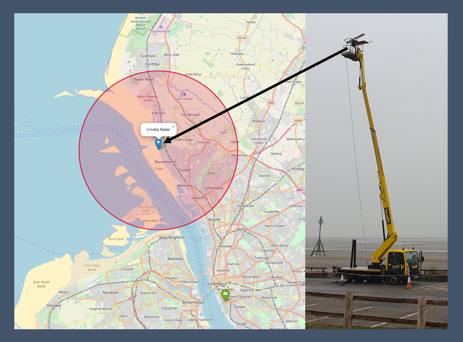
Working in collaboration with Sefton Council, Natural England and ornithologists at Mott MacDonald, Marlan deployed a Synoptic 4D radar system to monitor the bird migration patterns at Crosby Beach autonomously. The aim of the project was to marry up the observations by the ornithologists with those gathered by the radar, in order to assess the viability of using radar in a long-term capacity for supplementing periodic ornithologist site surveys.
Lead Advisor for Natural England, Aurelie Bohan comments that “having a continuous long term data set of bird usage helps to inform our site management, further our knowledge of key hot spots for birds, develop our advice on appropriate siting of developments and could provide annual data on the key passage and overwintering periods for sites along the coast”.
Deploying Synoptic 4D
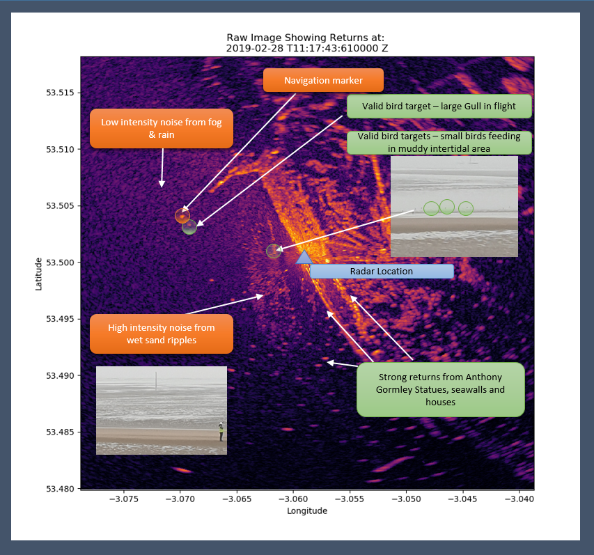
Marlan deployed a Synoptic 4D system mounted on an 18m MEWP for a 3-hour period to monitor and track bird activity in the surrounding area. The Synoptic 4D system combines the recording and storage software provided by IRIS radar with the big data analytics capabilities of Synoptic 4D (also capable of monitoring hydrography and hydrodynamics in the local environment). By tracking the bird targets detected over a wide area (the radar instruments to 6 km and the region of interest is ~3 km x 2 km), the system is able to observe not only birds, but also humans and dogs.
Quantifying disturbance events
After this observation was concluded, the raw data were then processed and filtered to produce binary images, showing activity blobs that were then tracked over a long period of time. Some blobs intersected with each other, for example in the image/video below, a person can be observed walking west across the beach, before approaching a flock of birds and causing them to lift and scatter.
Disturbance events such as these are, of course, very common on all of our beaches; however, the impact upon the roosting and feeding patterns of bird populations is currently not well understood. As Kimberley Anne Bowman, Ecologist & Ornithologist at Mott MacDonald states,
“Disturbance events causes extra (and unnecessary) time in flight (fleeing/prey species behaviour), which is the most energy consuming activity a bird species can do, and thus, more food and foraging time is needed to compensate for the total loss of energy expenditure during a particular disturbance event encountered.”
Constant autonomous observation through radar systems enables ornithologists to record and monitor these events more effectively, alongside quantifying their impact in terms of lost opportunities for bird roosting and feeding.
Cost-effective real time monitoring
This new development adds a valuable capability to the existing datasets produced by Synoptic 4D: intertidal topography, bathymetry and hydrodynamics. Marlan’s Synoptic 4D radar systems provide cost-effective autonomous monitoring for improving the quality of ornithological surveys at sites of scientific interest. The system offers valuable insights into the migration and feeding patterns of overwintering birds across the coast and allows for effective monitoring of disturbance events during busy activity seasons or construction projects. Through combining this research with data gathered from other Synoptic 4D systems, Marlan’s software provides an innovative and valuable tool for understanding the dynamic coastal habitats across the UK.